In early March, we all go a little crazy here in western Massachusetts. It’s been snowing since November, and there’s no guarantee that it will stop until May. In March, local stores start advertising “cabin fever” sales. Local families attempt to sell themselves on eBay. We’re all looking for an excuse to get out of the house, and more or less anything will do.
Looking back through some old photos this evening, I realize that March is my best month for photography. I seem to react to cabin fever by engaging in my favorite hobby: milling.
Milling is a variant on a phenomenon some call “urban exploration“. We don’t have too many urbs around here, but we have a wealth of beautiful abandoned mills. Milling involves finding ways into these mills and photographing them. This, in turn, involves driving around looking for promising looking mills, scouting them out and returning with milling gear (steel-toed boots, good flashlights, reflectors to bounce light, cameras, tripods…)
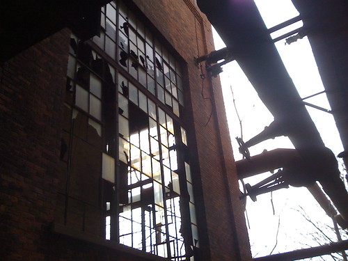
So I was scouting yesterday afternoon when I came across an utterly beautiful collapsing mill in the south side of Troy, NY. I started following back roads to get closer to the buildings, and was stunned to discover that I was able to drive up to some of these hulking wrecks, climb out and start shooting photos – generally, milling requires you to park a truck and hike into sites, climbing fences, crossing railroad tracks, wading streams. I shot photos with my phone until my battery ran out and drove out… straight into the parking lot of the Rensselaer county jail.

Looking for an access road that didn’t take me past a couple dozen of Troy’s finest, I discovered that the site I’d been exploring was blurred out on Google Maps. I’d read about sensitive sites – like the Vice President’s house or Dutch military bases – blurred out on Google Maps. I’d read enough on the issue to know that this probably wasn’t Google’s fault – some government authority had approached a satellite imagery provider and demanded that a feature be obscured. And I quickly discovered that the same site was unblurred on Yahoo Maps, though not available at the level of resolution that most of Troy is on Google Maps.
Still – this was the first time I’d found myself at a location in the real world that was invisible to Google Maps. Why would someone so carefully obscure this area, leaving the jail’s basketball courts visible a few hundred meters away? And if it was so important to obscure it, why was it so easy to get into?
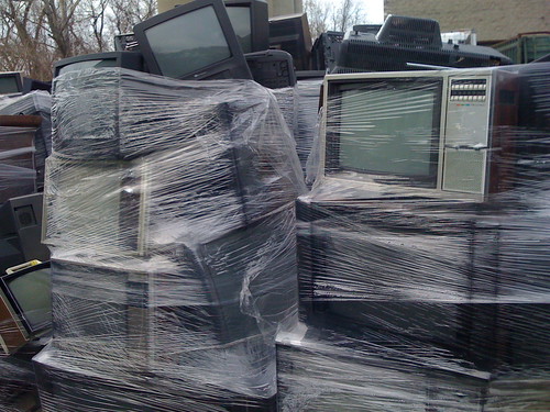
The ease of entry is pretty easy to explain. Based on the site is an electronics recycling company called eLot. The eLot folks are in the business of disposing of old computer hardware, televisions, comact fluorescent light bulbs, and the other detritus of our digital age. While they probably don’t get a whole lot of walk-in business, they do maintain a store, where you can pick up desktop computers for $59, or old Cisco switches. While they’re not open on Sundays, the site is open so that trucks full of dead televisions can be offloaded.
So why’s a publicly accessible site blurred out on maps?
Here’s my guess, based on a little 19th century history, and a bit more recent history. The site I was exploring (and intend to explore again, just as soon as I can find a better way in) is part of the Burden Ironworks. Built by Scottish inventor Henry Burden, the Ironworks harnessed the flow of the Wynantskill creek towards the Hudson river to power an automated horseshoe making machine. The machine was a wonder of the industrial age, and featured the largest vertical water wheel in the world, a 250 ton beast that produced 300 horsepower.
The Burden Ironworks converted from water power to gas in the late 19th century, and the wheel was abandoned in 1890, collapsing about twenty years later. From what I can tell from old maps, the northern part of the Burden complex has evidently been razed and replaced with the Rensselaer county jail – the southern part, which features the gas boilers, is still partially standing, and is the facility I began exploring. I’m looking forward to visiting the Burden Ironworks museum, which stands in the facility’s former office building, at some point soon – as it’s open by appointment only, that might require a bit of planning.
There’s a move to renovate some of these historic industrial structures. At least, there was. The Rensselaer Iron Works, just up the river from the Burden Ironworks, was purchased from its owners by the city of Troy, and New York governor David Patterson had announced plans in April 2008 for the building – post-renovation – to become the hub of an ecological monitoring center to track pollution across 315 miles of the Hudson. Less than two months later, the buildings were burned to the ground in a case of probable arson.
The gorgeous Lost Landmarks of Upstate New York website features a photo tour of the ruined buildings before the fire, noting that one of the mill buildings had been damaged by an earlier arson, and that the remaining structures were filled with abandoned cars and boats. While I can construct a narrative of someone in the Troy underworld realizing that a corpse hidden in an abandoned Edsel was going to be discovered in the renovation… but it’s as likely that someone decided to burn the building down because they were bored.
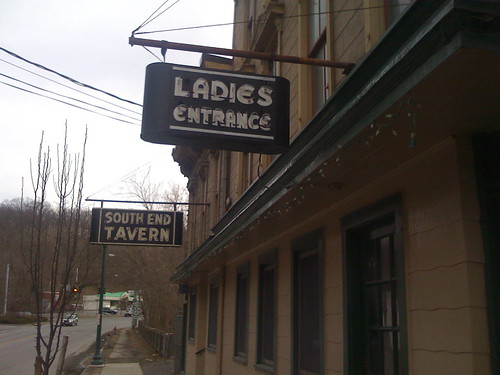
My guess for why the Burden site is blurred out – to help prevent future arson. That seems crazy to me, but I don’t have a more plausible explanation. I know that I use Google Maps to plan my routes into mills, and for all I know, arsonists do the same. Given that accessing the site involves little more than parking behind Marty Burke’s South Side Tavern and strolling in, this seems like overkill, but I’ve got no better explanation. If urban explorers, millers or Troy historians have a better explanation, I’d love your input on the comments thread.
Terrific story about milling in South Troy! I’m curious about the web-map black-out – it simply HAS to be something other than arson. If arson were reason to black out buildings on GoogleMaps, half of Boston would be included. (Jamaica Plain, my new neighborhood, seems to have a particularly nasty arson problem – and by this logic, nearly every black church in America might justify such ‘protection.’)
I don’t have a better answer except a conspiratorial hunch that there is either toxic pollution or formerly secret gov’t stuff located there.
Either way, it seems odd to me to black-out a sight on the web but leave it so accessible to a guy and his truck… Hmm..
This exhibit from the folks at the Center for Land Use Interpretation is at the Rensselaer County Historical Society in Troy. I saw it in NYC last June; it’s not huge, but I thought it was pretty nifty.
Pingback: …My heart’s in Accra » For the agrarian insane
THE OLD MILL HAS BEEN CALLED A BROWN FIELD. THERE HAS BEEN CLEANUP ALONG THE RIVER AND IN THE SITE BY COMPANIES THAT WOULD’NT REVEAL THIER INTENTUION OR FINDINGS EVEN AFTER I INFORMED THEM OF THE RIGHT TO KNOW LAW.
my grandfather owened the ideal tavern. would like to get more info. his name was mike carnavalle
Comments are closed.